File:Culebra map of beaches bays cays and attractions.jpg

Original file (1,347 × 1,115 pixels, file size: 519 KB, MIME type: image/jpeg)
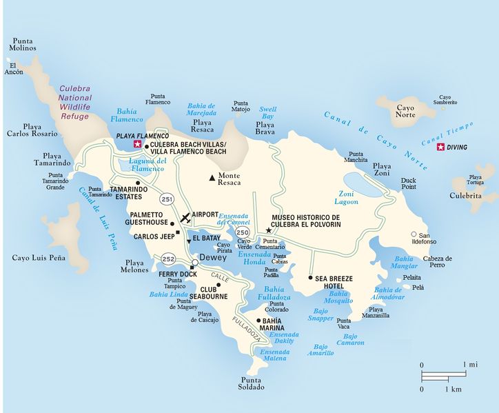
Map of Culebra island, Puerto Rico.
Includes the following features often left off of other maps:
Bahia de Almodovar Bahia de Marajada
Bahia Manglar
Bahia Mosquito
Bajo Amarillo
Bajo Camaron
Bajo Snapper
Cabeza de Perro
Canal Tiempo
Cayo Pirata
Cayo Sombrerito
Cayo Verde
Duck Point
El Ancon
Ensenada Dakity
Ensenada del Coronel
Ensenada Malena
Pela
Pelaita
Playa de Cascajo
Playa Manzanilla
Punta Cabras
Punta Cementario
Punta Colorado
Punta de Maguey
Punta Flamenco
Punta Manchita
Punta Matojo
Punta Padilla
Punta Tamarindo
Punta Tamarindo Grande
Punta Tampico
Punta Vaca
San Ildefonso
Swell Bay
File history
Click on a date/time to view the file as it appeared at that time.
| Date/Time | Thumbnail | Dimensions | User | Comment | |
|---|---|---|---|---|---|
| current | 17:40, 29 May 2017 | | 1,347 × 1,115 (519 KB) | MyWikiBiz (talk | contribs) | Map of Culebra island, Puerto Rico. Includes the following features often left off of other maps: Bahia de Almodovar Bahia de Marajada Bahia Manglar Bahia Mosquito Bajo Amarillo Bajo Camaron Bajo Snapper Cabeza de Perro Canal Tiempo Cayo Pira... |
You cannot overwrite this file.
File usage
The following page uses this file: